Coos Region...Adventure on Every Trail
Barklow Mountain
Barklow Mountain Hike--Sunday, September 25, 2016
Hike Description
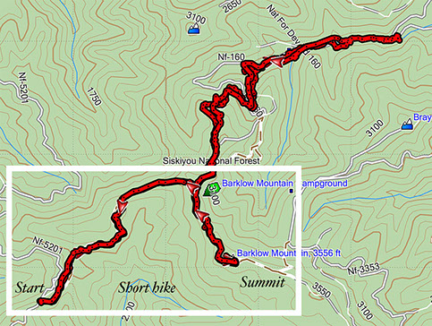
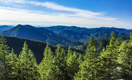
This trail follows the ridge to the location of the old fire lookout on the highest point of Barklow Mountain at 3,579 foot elevation. The trip to the summit and back is 3.7 miles out and back with a 1100 foot elevation gain and is rated difficult. This spot offers excellent views of the Siskiyou Mountains.
We will all go to the summit together then those who want a longer and more difficult hike can continue along the north ridge of Barklow Mountain to the east trail head at FS-3363 and return to our starting point for a total hike of 8 miles rated - most difficult. Most of this trail is within the Copper-Salmon Wilderness. The 'most difficult' rating is based on the steepness of the trail back.
This is a difficult and steep rocky trail, so walking sticks and boots with good ankle support are highly recommended.
Bring plenty of water, lunch and dress appropriately for either warm or cold rainy conditions and windy exposed areas.
There may be some bush-whacking on the longer hike so bring your gloves and wear long pants and long-sleeved shirts.
We are traveling on gravel roads with pot holes, slumps, and some high centers. Passenger vehicles might scrub bottom occasionally, so high clearance vehicles are recommended. We will try to consolidate in high clearance cars when we meet at Ray's in Bandon.
Location and Time
We will leave the parking lot of Ray's Grocery in Bandon at 7:30am
Directions to Ray’s in Bandon: Ray’s is located just off Hwy 101 on the North end of Bandon.
Suggested Carpool sites and departure times:
- Coos Bay Visitor Center 6:45am,
- Coquille Visitor Center 6:45am,
- Ray’s in Bandon 7:30am,
- Reedsport Visitor Center 6:00am.
*If you are coming from Curry County just meet us at intersection of Hwy 101 and CR 308 / Elk River Rd. We leave there at 8:00am sharp. Email Southcoaststriders@gmail.com if you plan to do this.