Bandon
Notes about Bandon, OR
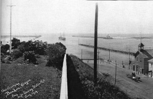
The channel leading into Bandon Harbor
This is a view in Bandon, looking West from the hill above First Street. It was taken in 1914. You’ll notice that the street runs into the water, and the channel allows some pretty good sized ships.
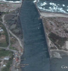
The image below (from Google earth) shows a similar area. In the lower left you can see that the street makes a left turn. All of the land beyond that turn was under water in the 1914 photo. Something else that’s interesting to note is that it would have been difficult now to take a photo like the 1914 photo. First, the property on the hill above first is in private hands. Second (and probably more important), the hill is covered with Monterey Cypress. Those were planted because they grow fast, can tolerate the wind, and possibly because Bandon wants to be the Carmel of Oregon. 🙂

